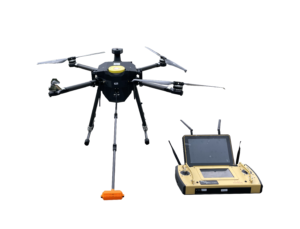
The ETG Drone pairs a tunable diode laser methane sensor with a custom Nimbus UAS airframe to survey emissions from the air. Operators plan a route, upload it and let the drone fly the mission automatically while the ground control station streams position and CH4 readings in real time. The platform is built to operate in a wide range of weather conditions and can be flown by staff after minimal training.
- TDLAS laser sensor measuring methane in ppm
- Custom-built airframe on the Nimbus UAS PPL418 platform
- Automated missions: plan, upload and fly without manual piloting
- Ground control station with live flight and gas data
- 5G link for precise, safe remote control
- Compatible with a range of GPS antennas
- 30 to 40 minute flight time with a 3.5 kg payload capacity
- Simple interface suitable for operators with minimal training
| Measured gas | CH4 (ppm) |
| Sensor technology | TDLAS laser |
| Airframe | Nimbus UAS PPL418 (Italy) |
| Flight time | 30 to 40 minutes |
| Maximum speed | 45 km/h |
| Maximum payload | 3.5 kg |
| Control | 5G link, ground control station, GPS |
| Operation | Automated missions |
- Pipeline methane leak detection
- Landfill surface emissions surveys
- Livestock farm emissions mapping
- Oil and gas facility monitoring
- Waste management sites
Datasheet / brochure not available to download at the moment – to be added by the developer.